 Regional Rail Maps
JET Task Force Proposal
This historical plan is based on the map in the August 15, 2014 presentation before the Jobs, Expansion, and Transportation Task Force, which describes one main route and two optional alignments for a light-rail connection between the Airport and Downtown.
This route was only part of the JET Task Force’s final report. The Task Force was charged with “developing recommendations on how best to strengthen our airport area as an economic hub and the center of transportation for the region”1, with recommendations covering many policy fields. Among their recommendations were more direct flights from Columbus to the West Coast and Europe, building a “multimodal transportation center” at the airport, investing in all modes of freight transport, bringing more industry to Columbus, and making lots of public-private partnerships. The Task Force compared the state of Columbus in 2014 to other major cities, and found Columbus lacking.
One of the ways that Columbus was lacking — and still is — is the absence of a rail connection between the Airport and Downtown. They wanted this rail system to be part of a larger network, and, unfortunately, they only designed the airport part of the network.
Routes
- JET route
- The primary route identified by the JET Task Force runs along High Street from the Statehouse to the Convention Center, then along Goodale Boulevard before using a tunnel to cross under 670 and the railroad tracks. It continues east along the north side of the railroad tracks to Cassady Avenue, then onto Johnstown Road and East 17th Avenue before entering the airport on International Gateway.
- Option A: Airport
- This route runs on Nationwide Boulevard and Neilston Street through the Abbott plant, and connects to the Convention Center Hyatt instead of the Convention Center itself.
- Option A: East
- This route runs on Leonard Avenue and 5th Avenue, crossing 670, instead of using the existing rail right-of-way.
- Option B
- This route runs up Cleveland Avenue, then east on 5th Avenue, before joining with Option A East to connect to the airport
This system includes a lot of street running, and I’m worried that future Columbus planners might choose to adopt this goal. As we’ve seen with Cincinnati’s street car, running trains on the street means that your trains are blocked by every car accident and illegally-parked delivery driver, and your trains will never be faster than the private cars they’re trying to replace.
Stops
The JET Task Force didn’t identify any specific stops in their report, but they did mention several destinations. I’ve taken the liberty of plotting those destinations on the map:
- The Statehouse stop is where most major bus lines stop to exchange passengers.
- This stop is on the north end of the convention Center, at Goodale Boulevard
- Cleveland Avenue connects to the CMAX line, bringing Westerville passengers to a two-seat trip to the airport. This stop also services Abbot Nutrition, a major employer, and the Fort Hayes Metropolitan Education Center. This area of the city is almost completely cut off from surrounding neighborhoods, so building a stop here provides access to educational opportunities to the rest of the city.
- Joyce Avenue connects to Devon Triangle and Mount Vernon, and is just a hop away from King-Lincoln Bronzeville.
- Leonard Avenue connects to Devon Triangle and Woodland Park neighborhoods.
- An island station on 670 connects to Nelson Road underneath, the 670 Bikeway, and the Amazon DCN2 facility.
- The JET task force strongly recommended creating a hub for interstate buses near the airport. This seems to be the best place to place it.
- Future location of rebuilt CMH terminal
Major Construction
The report also identified several related construction projects which would be part of the light-rail project:
- Downtown Tunnel
- The JET Task Force report identifies a tunnel may be needed in this section to connect the line from the Convention Center station on Goodale Boulevard under 670.
- Maintenance Yard Option 1
- This maintenance yard is compatible with the proposed route or Option A
- Maintenance Yard Option 2
- This maintenance yard option is compatible with route Options A and B
- Rebuild Bridge
- The JET task force seems to believe that the tram would cross the rail yard on the Leonard Avenue bridge. Since this is currently a two-lane road bridge, it would need to be rebuilt to accomodate trains.
- Rebuild Bridge
- The JET task force seems to believe that the tram would cross 670 on the 5th Avenue bridge, which would need to be rebuilt.
Significance
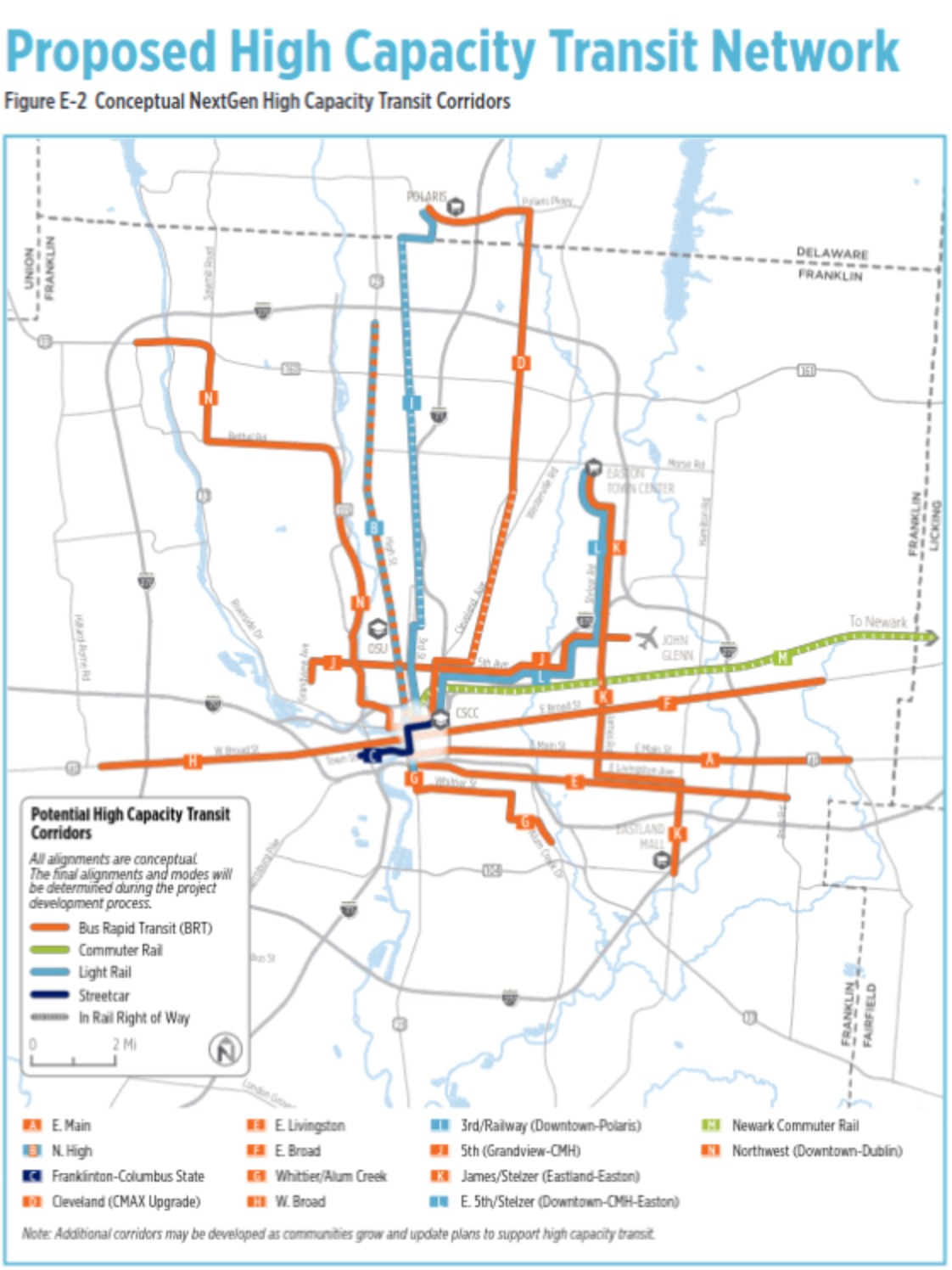
This historical plan’s significance comes from its influence: The JET Task Force report was influential in COTA’s 2017 NextGen plans. The route of NextGen’s proposed light rail line takes follows the JET Task Force proposal:
The 2019 Insight 2050 Corridor Concepts report did not include an airport connection, but that map was reproduced in COTA’s May 2020 Short and Long Range Transit Plan, which covers plans to be implemented in 2020-2050.
These plans have been obsoleted by the LinkUS initiative for transit improvements in Central Ohio. LinkUS’ 2022 Community Action Plan included an approximate corridor for a Downtown-CMH-Easton route:
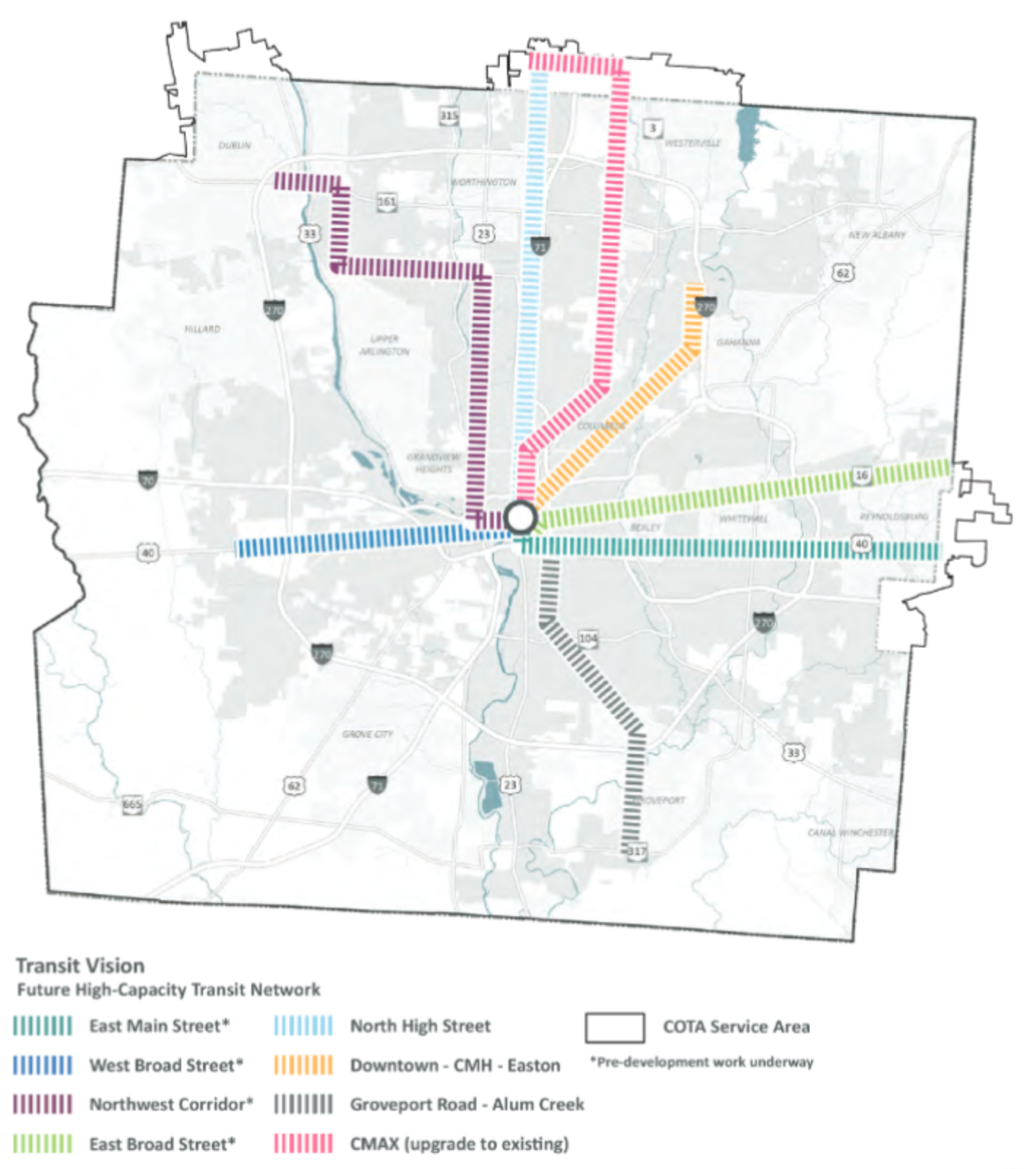
As I write, it’s December 2023, and the LinkUS plan is moving on from the initial three corridors to begin planning the fourth and fifth corridors.2 The future planning work for MORPC’s corridors might result in a good alignment, or it might result in bad surface running. Who knows?
Citations
-
JET Task Force Final Report of Key Findings and Recommendations, February 25, 2015. ↩
-
No link for this one, alas; they only published this news in an email newsletter. ↩